BBlogFlow

Categories

Weather

4013 articles

Weather

Ask a met: Polo, Nolo, Lala? What's the deal with these Pacific hurricane names?

"Polo, Nolo, Lala? What's the deal with all the Pacific hurricane names that are just two repeating syllables? " — KevinA lot of this comes down to coincidence and time of the year, but there are some linguistics embedded in the Central Pacific names that tipped the chances of repeated syllables. Let’s start with Marco Polo, err… Polo 'n Nolo. These are the names that have gotten the most chatter in the newsroom and online in the last few weeks. Coincidental timing of names has been a theme this year, starting with Tropical Storm Dolly being named within days of Dolly Parton’s death. That name first appeared on naming lists when Dolly Parton was just 7 years old. It happens to be on a list that rotates every six years, and nobody knew or planned for that name to be on the list in the same year the beloved singer and philanthropist would pass. Likewise, Polo is on another rotating list that appears every six years and goes from A to Z through the year. This was just the 16th storm of this season in the East Pacific. Polo isn’t a popular name in English-speaking countries, but it is a nickname in Spanish and Italian for common names like Paolo and Pablo.

The Weather Channel·
Weather

Sponge cities explained: how cities can absorb rainwater

Sponge cities: What makes a city soak up rain instead of flooding? Cities are no strangers to urban flooding. Excessive runoff from clogged storm drains can be a common occurrence. But we may be hearing the term “sponge cities” more often. These creative cities are working to fight back and come up with ways to absorb rainwater rather than just letting it head to the drains. The term "sponge cities" was coined by Chinese landscape architect Kongjian Yu to describe ways for urban areas to fight back against flooding. Cities are working to reduce the amount of rainfall running into storm drains to protect ecosystems downstream. (Getty Images)The bottom line Whether your city shrugs off a downpour or ends up flooded often boils down to one key factor: how much water its surfaces allow to pass through. The Environmental Protection Agency (EPA) discovered that a parking lot is roughly 95% impervious. Rain basically hits and runs straight to a storm drain. Natural land cover is basically the opposite. Since it is close to 0% impervious, water soaks in and moves slowly through soil.

The Weather Channel·
Weather

What El Niño means for your Halloween forecast and costume

El Niño may mean you need backup plans for your Halloween costumeHalloween is lurking around the corner like the murderer in a slasher film (sorry for the jump scare!). The weather can play a big role in what you and your kids decide to wear for trick-or-treating. And this year, El Niño could cast a spell on the forecast for your candy collection. While El Niño doesn’t guarantee anything (it’s just a climate pattern, after all), it can tilt the forecast odds one direction or the other, and that might mean you need to adjust your costume to accommodate for the weather. People fall into two camps: Those who’ve been planning their Halloween costume for a full year and might need to make tweak it, and those who’ll just make like a bat and wing it. But El Niño has a few tricks (and maybe a few treats) up its sleeve. The Trick: The South trends wetterEl Niño nudges the subtropical jet farther south and turbocharges it, causing wetter than average conditions in the southern tier of the U.

The Weather Channel·
Weather

Record wettest or record driest? Autumn started with stark divisions

El Niño left its fingerprints all over the beginning of autumn across North America as heavy rains brought deluge to some communities and left neighbouring areas high and dry. A striking pattern developed throughout the continent as plumes of tropical moisture streamed from both the Gulf and the Pacific. Intense deluges brought significant totals to areas that hardly see any rain this time of year. DON’T MISS: Staying safe from flash floods, a serious and deadly hazardSharp contrasts between soaked and parchedThe overall setup across North America during the first month of autumn magnified rainfall extremes in both directions. A stubborn ridge of high pressure over the Southeast kept the active storm track flowing from the U. S. Southwest toward the Midwest, largely missing southern Ontario as it plunged back toward the south. Many communities from southern New Mexico to central Iowa saw one of their wettest Septembers on record after the extremely active eastern Pacific hurricane basin pumped excess moisture inland. Albuquerque, New Mexico, picked up nearly 400 per cent of its normal monthly rainfall.

The Weather Network·
Weather

Fort Worth middle school deemed 'unsafe for occupancy' because of damage from intense storms that slammed area

According to the FOX Forecast Center, 3.40 inches of rain fell on the Fort Worth area on Thursday alone. Texas in bull’s-eye of flood threat as 50M from Southern Plains to East Coast face Friday soaker The major Texas cities of Dallas, Austin and San Antonio face another round of potential flash flooding as thunderstorms fire along an 1,800-mile front draped border-to-border from South Texas to Upstate New York. More than 50 million people are under a flash flood threat, with another round of heavy rain fueled by tropical moisture expected to move into the Southeast this weekend. THE TAKEAWAYHeavy rain caused damage to a Fort Worth middle school. The staff and students will relocate to a nearby elementary school. Nearly 3.5 inches of rain fell on Fort Worth area on Thursday. FORT WORTH, Texas – A Fort Worth Independent School District (ISD) middle school has been deemed ‘unsafe for occupancy’ due to damage from recent storms. The Superintendent of Fort Worth ISD, Dr.

Fox Weather·
Weather

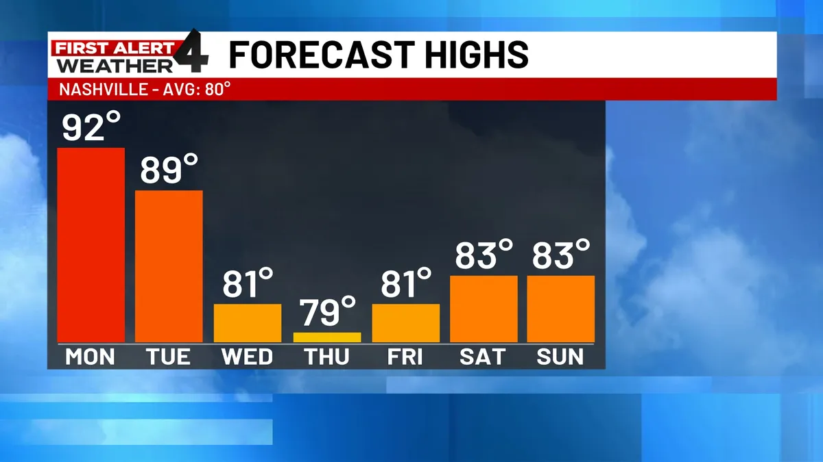
Nashville Weather: Hottest Day of Year, Cool Down Mid-Week — May 18, 2026

NASHVILLE, Tenn. (WSMV) - Today was the hottest day of the year. Cooler weather is on the way mid-week along with rain and thunderstorms. This is the Sunday 10 p.m. newscastTHE NEXT 24 HOURS:Clear and warm tonight. Lows only fall to the upper 60s overnight, so it will start off very warm Monday morning. It will be hot again with lots of sunshine and a high near 90. For life-saving weather alerts, customized messages on conditions and forecasts, and videos detailing upcoming weather events, download the WSMV 4 First Alert Weather app for iPhone or Android. Have weather pictures or videos? Share them here. Get More of Our News on GoogleSet The Weather Company as a 'Preferred Source' to get quicker access to the news you value. MONDAY’S FORECAST:Morning- Starting off warm in the upper 60s. Afternoon- Mostly sunny and hot with highs in the low 90s. Evening- Staying warm all night with lows in the 70s. TUESDAY’S FORECAST:Morning- Starting off very warm in the 70s. Afternoon- Highs in the upper 80s. A dry start to the day, then rain showers and thunderstorms move in later in the afternoon. A few thunderstorms could be strong especially to the northwest.

The Weather Channel·
Weather

Nashville Weather: Strong Storms Possible Monday Night — May 19, 2026

NASHVILLE, Tenn. (WSMV) - FIRST ALERT WEATHER DAY - LATE TUESDAYA batch of thunderstorms moving in from the west Tuesday evening could create a damaging wind gust or two. These storms will be weakening as they arrive in Middle Tennessee, so areas well west of I-65 will have the best chance for downpours and isolated strong wind gusts. The timing for strong storms is 7 p.m. - 11 p.m, Tuesday. Nashville’s chance for severe weather is very low. Have weather pictures or videos? Share them here. NEXT 24 HOURSGet More of Our News on GoogleSet The Weather Company as a 'Preferred Source' to get quicker access to the news you value. Mainly clear, warm, and humid tonight. Lows will be in the low to mid 70s. Tuesday will be a lot like Monday -- partly cloudy, hot, and humid with an occasionally gusty wind. Late Tuesday, an isolated shower or storm will be possible. TOMORROW’S FORECASTMorning- Starting off very warm and dry in the 70s. Afternoon- Highs near 90. A dry start to the day, then rain showers and thunderstorms move in later in the afternoon. A few thunderstorms. Evening- More scattered showers and storms in the evening and early into the overnight.

The Weather Channel·
Weather

Nashville Weather: Daily Rain & Storms Through Weekend — May 20, 2026

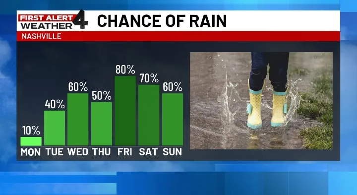
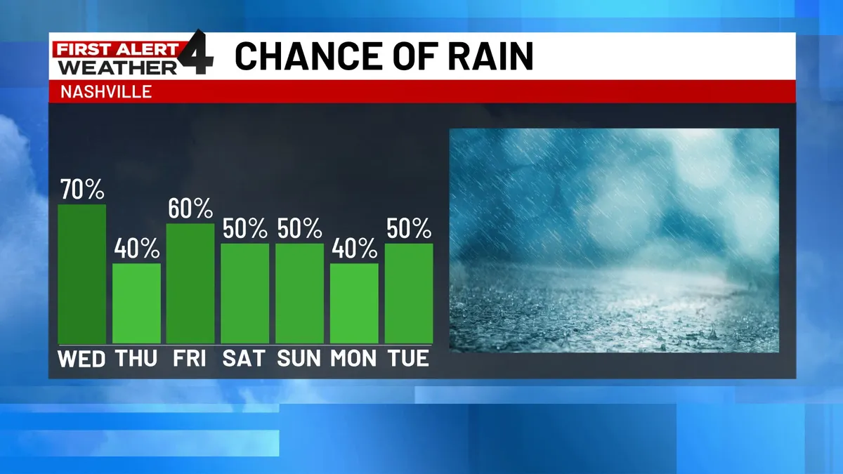
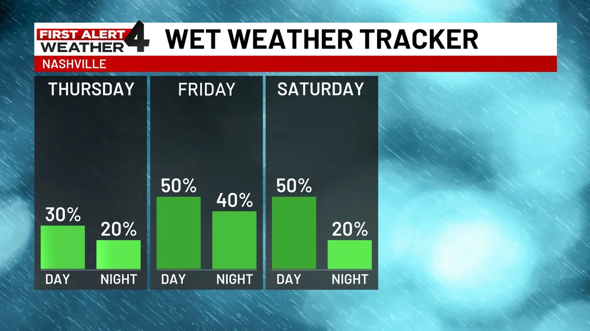
NASHVILLE, Tenn. (WSMV) -Unsettled weather pattern with rain and thunderstorms through the Memorial Day holiday. NEXT 24 HOURSYou’ll want to have the wet weather gear ready, with off-and-on rounds of scattered showers and thunderstorms expected throughout the day. There will be dry periods at times, but thunderstorms could bring some heavy downpours along with them. Highs today will top off in the upper 70s to near 80. Tonight a few showers and thundershowers continue. Low 64. Tomorrow be ready for morning rain, with some hit or miss thunderstorms in the afternoon. Highs in the upper 70s Thursday. Have weather pictures or videos? Share them here. Get More of Our News on GoogleSet The Weather Company as a 'Preferred Source' to get quicker access to the news you value. THURSDAY’S FORECASTMorning: Cloudy and slightly cooler with a few areas of rain. Low, 64. Afternoon: Mostly cloudy and mild with a few spots of rain (best chance along and south of I-40). Rain chance, 40%. High, 76. Evening: Mostly cloudy with isolated spots of rain. FRIDAY’S FORECASTPeriods of on and off rain and thunderstorms throughout the day. Storms could produce heavy rain, but there is no severe weather threat.

The Weather Channel·
Weather

Nashville Weather: Weekend Rain & Storms Expected — May 28, 2026

NASHVILLE, Tenn. (WSMV) -After a rain break for most areas, more rain and thunderstorms are expected this weekend. Less rain and humidity expected next week. NEXT 24 HOURSWarm and VERY humid with a spotty shower or storm this afternoon, especially south, but most areas will be dry. Some sun will break through the clouds at times with temperatures in the upper 80s for the day. With the humidity factored in, it may even feel like over 90 this afternoon. Tonight, will be partly cloudy and humid, low in the mid-60s. For life-saving weather alerts, customized messages on conditions and forecasts, and videos detailing upcoming weather events, download the WSMV 4 First Alert Weather app for iPhone or Android. Have weather pictures or videos? Share them here. Get More of Our News on GoogleSet The Weather Company as a 'Preferred Source' to get quicker access to the news you value. TODAY’S FORECASTAfternoon: Warm and humid with a spotty shower in the afternoon. Some sun will break through the clouds at times with temperatures in the mid-80s for the day. Evening: Mostly cloudy, low in the upper 60s. FRIDAY’S FORECASTMorning: Partly cloudy and warm. Low, 66.

The Weather Channel·
Weather

Nashville Weather: Rain Returns, Warmer Temps Ahead — June 9, 2026

NASHVILLE, Tenn. (WSMV) - Rain returns to the forecast today and will stick around for a while. Temperatures will also warm up this week. NEXT 24 HOURS:Starting off warm and partly cloudy this morning. Rain showers begin to develop this afternoon. It will be spotty, but some isolated thunderstorms will bring heavy drenching downpours and maybe some gusty wind. Thunder and lightning will be possible, too. Temperatures will be in the lower 80s and very humid. Rain begins to clear out later tonight. SUNDAY:Morning- Partly cloudy with temperatures in the upper 60s. Afternoon - Hot and humid with highs in the lower 80s. Rain and storms develop throughout the day. Get More of Our News on GoogleSet The Weather Company as a 'Preferred Source' to get quicker access to the news you value. Evening - Rain begins to clear out. Lows fall to the low 70s. MONDAY:Morning - Mostly cloudy and warm in the 70s. Afternoon - Hot and humid again. More scattered rain and storms. Most of the rain will be in the Plateau. Evening - Lingering rain showers. Lows in the low 70s. REST OF THE WEEK:It will get warmer through the rest of the week and also very humid.

The Weather Channel·
Weather

Cleveland Weather: Sunny & Dry, Warming Up — June 8, 2026

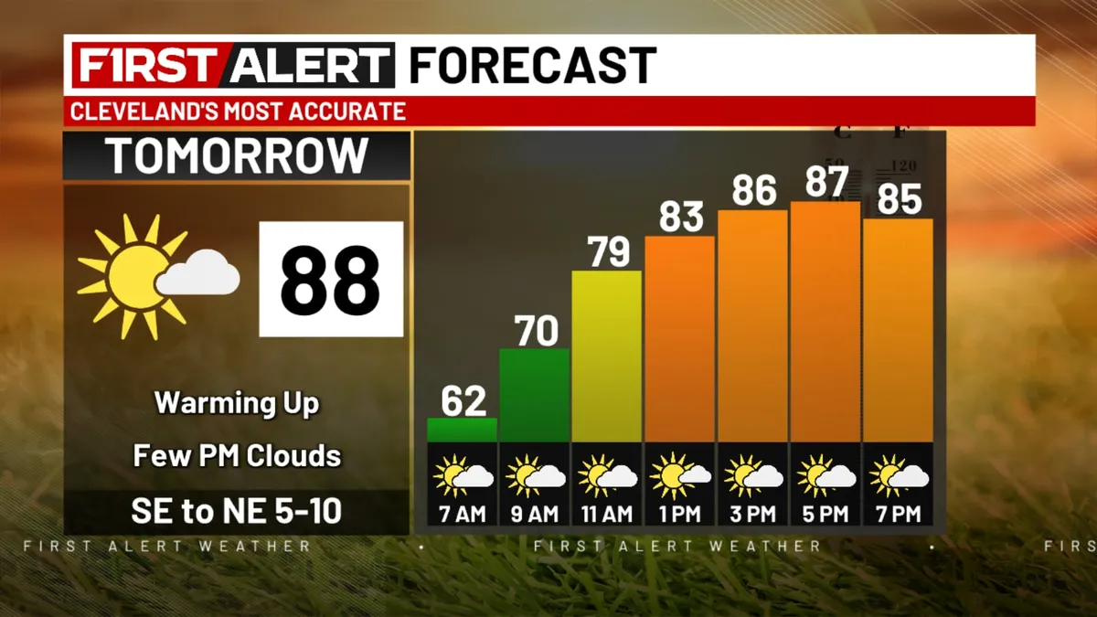
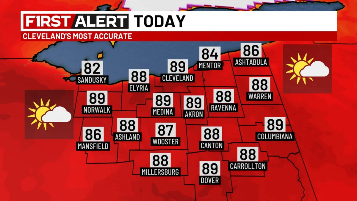
CLEVELAND, Ohio (WOIO) - A beautiful end to the weekend leads us into a quiet start to the week. Mostly clear skies tonight will drop temperatures into the upper 50s and low 60s. Monday starts the work week off on a quiet note. Temperatures will be heating up as will the humidity. Highs will warm into the upper 80s. A few clouds build through the day that could lead to an isolated rain chance by evening for areas west of I-77. The rest of the week features more humidity as well as a daily chance for rain and storms. Download the 19 First Alert Weather AppHumidity will be into the tropical category through much of this week fueling the potential for heavy downpours. Get More of Our News on GoogleSet The Weather Company as a 'Preferred Source' to get quicker access to the news you value. A chance for widespread showers will work into the region Tuesday. Daytime highs will be into the mid 80s Tuesday and Wednesday with more showers in the area. Activity will break up a bit more Thursday and Friday with scattered showers and storms still possible, but coverage not as widespread. Highs Thursday will warm into the upper 80s before a cooler trend sets in by the end of the week.

The Weather Channel·
Weather

Cleveland Weather: High Heat, Storm Risk Wednesday — June 10, 2026

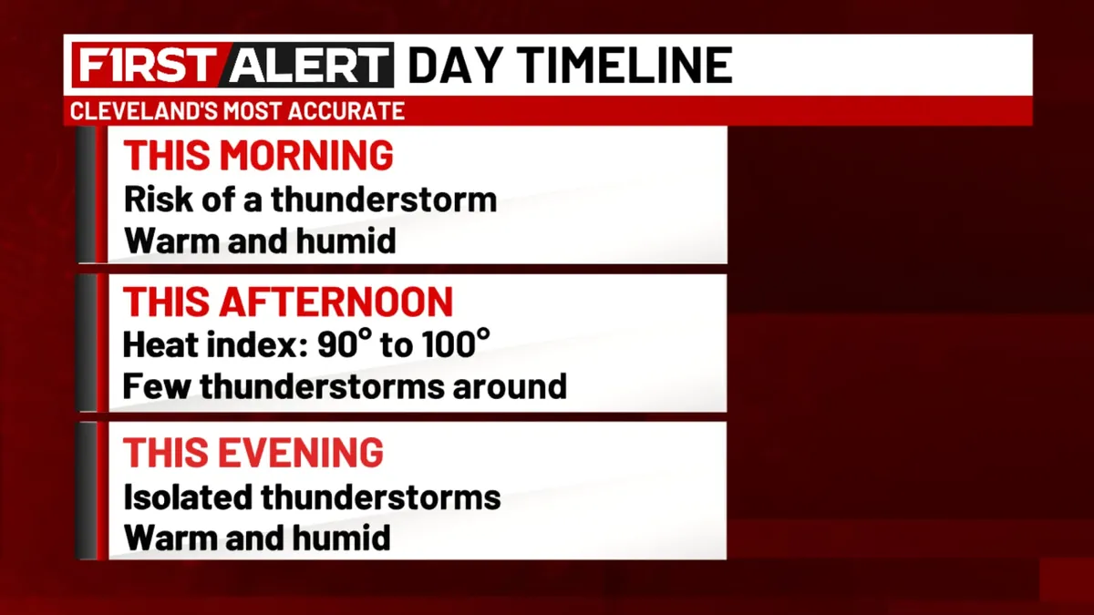
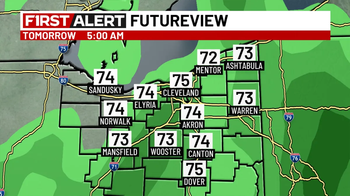
CLEVELAND, Ohio (WOIO) - Rounds of disturbances over the coming days will feed off of a lot of heat and humidity overhead. The first is expected to roll through tonight, driving in showers and non-severe thunderstorms. This will keep temps warm overnight - dropping them only into the low 70s. Expect this activity to clear by sunrise tomorrow morning. Download the 19 First Alert Weather AppMost of the day tomorrow will feature ample sunshine and very hot temps - reaching into the upper 80s and lower 90s. Get More of Our News on GoogleSet The Weather Company as a 'Preferred Source' to get quicker access to the news you value. High humidity will be a major issue to contend with during the day tomorrow as well. By the evening, the lake breeze, along with another disturbance will pop up a few more storms. These storms will tap into a ripe environment for hail and gusty winds to 60 mph. For that reason, we have issued a 19 First Alert Weather Day. Most of this activity will work in after 7 PM - just in time for post-work plans. By the overnight, things will clear once again. Thursday will feature another (yet lower) storm chance over the area.

The Weather Channel·
Weather

Cleveland Weather: Strong to Severe Storms Tonight — June 11, 2026

CLEVELAND, Ohio (WOIO) - Today is a 19 First Alert Weather Day as we track showers and storms across Northeast Ohio. Some of these storms could be strong to severe. More storms will work through the area overnight tonight, as another disturbance reaches the area after midnight. These storms will be ordinary in nature, though they could contain heavy downpours. These storms should last through the middle of the day tomorrow, before clearing later in the day. Temperatures will remain warm over the area, as highs will climb back into the upper 80s and lower 90s (with ample humidity overhead as well, making feels like temps climb into the upper 90s). Download the 19 First Alert Weather App  19 First Alert Weather RadarGet More of Our News on GoogleSet The Weather Company as a 'Preferred Source' to get quicker access to the news you value. A cold front will roll through late Thursday night into Friday morning. This will drive more showers and thunderstorms over the area, mainly during the morning hours of Friday. By Friday afternoon, northerly winds will drive in drier, comfier, and cooler conditions. Sunshine and 70s (with low humidity) is to be expected by Friday evening.

The Weather Channel·
Weather

Northeast Ohio Weather: Warm, Humid Week Ahead — June 9, 2026

CLEVELAND, Ohio (WOIO) - A series of fronts will be stalled near the region this week. As moisture increases, this means higher humidity but also numerous opportunities for showers and storms. A few showers may develop late tonight and move into the area, however, overall impact for most will be quite low. Low temperatures hover in the 70s overnight. Download the 19 First Alert Weather AppFor Tuesday, a couple showers are possible in the morning before scattered thunderstorms form during the afternoon. Get More of Our News on GoogleSet The Weather Company as a 'Preferred Source' to get quicker access to the news you value. High temperatures rise to the mid 80s. In fact, afternoon temperatures pretty much reach the 80s through the end of the week, but exact readings will depend on coverage and timing of storms. Storm coverage through Friday remains scattered, meaning some locations may receive frequent downpours while others come up with little to no rain. The weather team will continue to provide updates on exact details as new data becomes available. The weekend starts with drier and a bit more refreshing conditions on Saturday followed by renewed rain chances on Sunday.

The Weather Channel·
Weather

Northeast Ohio Weather: Humid, Isolated Showers — June 11, 2026

CLEVELAND, Ohio (WOIO) - A boundary will spark a few showers moving through the region this afternoon. Most locations stay dry as high temperatures reach the upper 80s. The humidity remains elevated, so “feels like” temperatures will be in the 90s. A few showers are possible overnight as a dying storm complex enters the region from the west. Low temperatures stay in the 70s. Download the 19 First Alert Weather AppGet More of Our News on GoogleSet The Weather Company as a 'Preferred Source' to get quicker access to the news you value. On Friday, a stray shower or two is possible in the morning, otherwise cloud cover decreases throughout the day. Humidity drops considerably as high temperatures hover in the 70s. Saturday will be dry and sunny as high temperatures reach the mid and upper 80s. Showers and storms are likely again on Sunday, followed by much cooler temperatures with much lower humidity Monday through Wednesday.

The Weather Channel·
Weather

Northeast Ohio Weather: Cooler, Less Humid — June 12, 2026

CLEVELAND, Ohio (WOIO) - Cooler and less humid air is building into the area today. The next cold front tracks through Sunday. Gradual clearing today. Afternoon temperatures 76 to 82 degrees. A clear sky tonight. Download the 19 First Alert Weather AppMostly sunny tomorrow. High temperatures in the 80s. A mild Saturday night with a partly cloudy sky. Overnight temperatures fall to around 70 degrees. Get More of Our News on GoogleSet The Weather Company as a 'Preferred Source' to get quicker access to the news you value. Thunderstorms in the area Sunday.

The Weather Channel·
Weather

St. Louis Weather: Severe Thunderstorm Watch Until 9PM — June 11, 2026

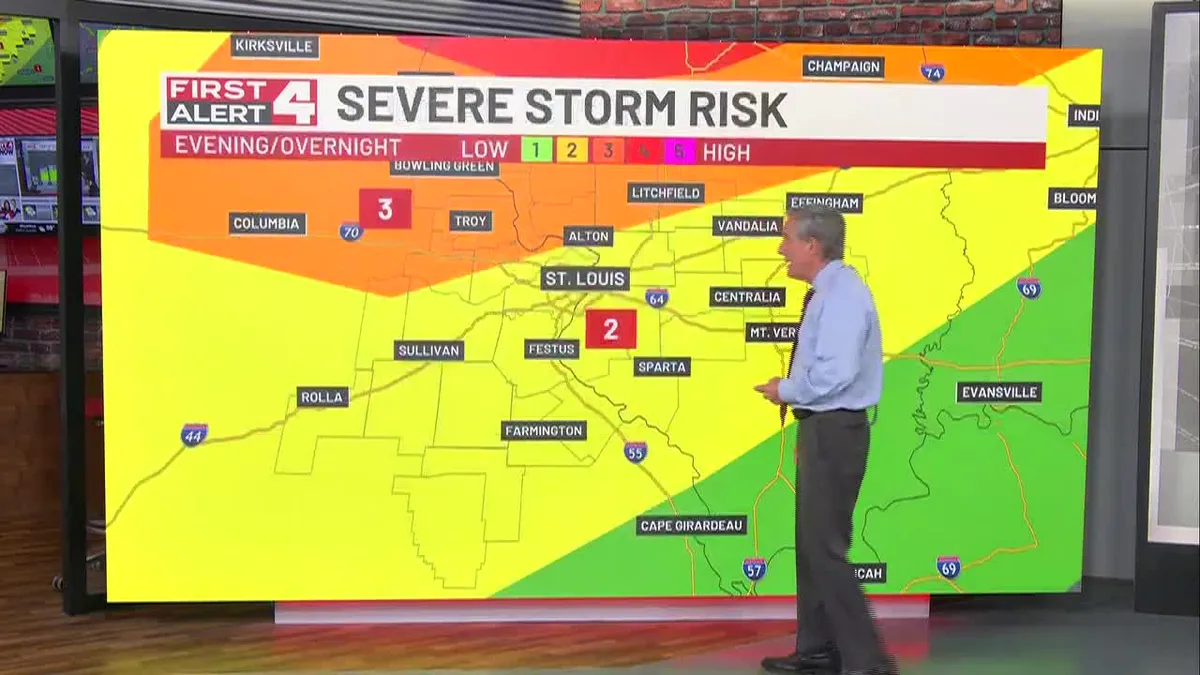
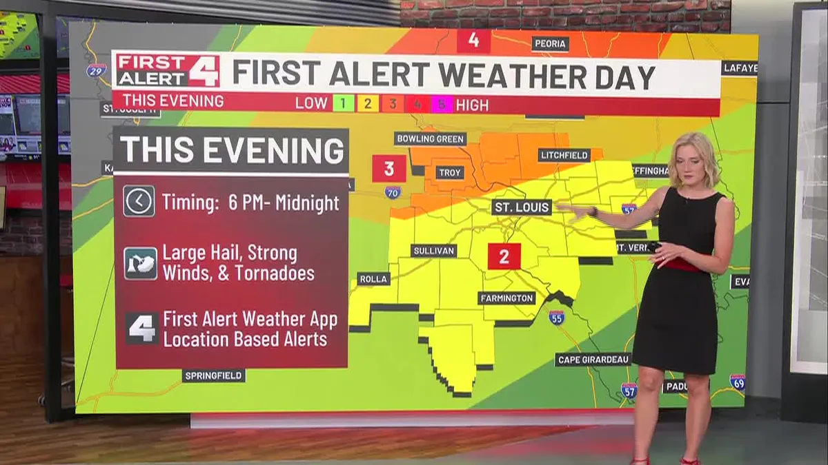
High Heat: Heat Index Up to 104°Evening-Overnight Strong to Severe StormsCooler Friday Into Early Next WeekDownload the Free First Alert Weather App HereFirst Alert: Severe Thunderstorm Watch Until 9pmThursday Is a First Alert Weather Day: First in line will be the dangerous heat as heat index values climb up to 104° (95° for the actual high) this afternoon with plenty of sunshine. Following this, our attention turns to strong to severe storms this evening. Starting at 6 pm into western portions of the region (Gasconade, Warren, Phelps, and Pike counties), strong to severe storms look to move east approaching the STL Metro area closer to 8-10 pm. The severe risks for storms continues through the rest of the region lasting until midnight. Strong winds, large hail, and a few tornadoes remain possible as the primary threats. Friday: After the cold front drives the storms out of the region well before sunrise Friday morning, temperatures will remain cooler heading into and through the weekend.

The Weather Channel·
Weather

St. Louis Weather: First Alert Storm Risk Tonight — June 11, 2026

Storms Continue TonightCooler Friday Into Early Next WeekFirst Alert Weather Day On SaturdayDownload the Free First Alert Weather App HereThursday is a First Alert Weather Day: The severe storm risk continues across the rest of the region through midnight. Strong winds remain the primary risk, but we’ll watch in case of a brief spin-up tornado. Just because they spin up quickly doesn’t mean they won’t cause damage. If you’re in a warning, seek shelter. The storms are moving quickly and will only impact any particular location for about an hour before moving out. Friday: After the cold front drives the storms out of the region well before sunrise Friday morning, temperatures will remain cooler heading into and through the weekend. Saturday is a First Alert Weather Day: Scattered showers and storms remain possible Saturday lasting through Sunday morning, some of these storms could be stronger on Saturday as the cold front moves in. We’re in a threat level 2 out of 5 for severe weather. What’s Next: After the storms, we get a reinforcing shot of milder temperatures and even some days in the 70s beginning on Sunday.

The Weather Channel·