Weekend washout to drench Southern Florida with relentless heavy rain and flooding
This story deserves to be shared
Send it to someone who'd care, or post it on your networks.
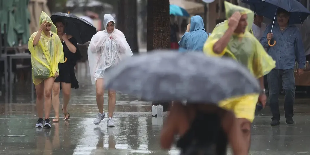
A level 1 out of 4 flash flood threat is in effect for Saturday and Sunday, with Fort Lauderdale and Miami included.
Florida faces wet weekend ahead of peak King TIdes Showers and gusty winds are powering up for the Sunshine State, where a level 1 out of 4 flash flood threat is in effect for South Florida. A widespread 2 to 3 inches of rain is forecast for the region. THE TAKEAWAYDays of nasty weather full of heavy rain and gusty winds will hit South Florida this weekend. A widespread 2 to 3 inches of rain is expected across the Southeast through Monday. Temperatures in the mid-to-upper 80s will make conditions uncomfortable amid thunderstorms and heavy rain. FLORIDA – Wet weather returns to parts of the Sunshine State this weekend, after brief relief, as persistent rain and strong wind gusts create a messy scene for thousands. A stalled frontal boundary is hanging over Florida, bringing soggy, gusty conditions through the weekend for southern portions of the state.
This article is an excerpt. To read the full content, visit the original source. Fox Weather
Related articles
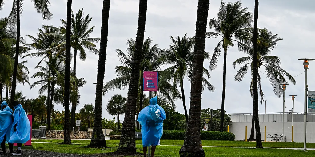
Northern Florida beach towns facing a coastal flood threat as relentless rain soaks region throughout the week
Relentless rain soak Northern Florida, triggers Flood Watches Soaking and relentless rains have been slamming the Sunshine State throughout the week, with up to 12 inches of rain already recorded in the Florida Panhandle. Flood Watches have been triggered along Florida's northern coast, from Jacksonville to Flagler Beach. THE TAKEAWAYA coastal storm has developed just off the northeastern Florida coast, bringing a coastal flood threat and high rip current risk for the First Coast. A Level 1 out of 4 flash flood threat remains in place across parts of the Florida Panhandle and from North Florida into Central Florida through Thursday. Flood Warnings and Flood Watches are in place along Florida's northern coast through Wednesday. The stretch of wet weather in Florida isn’t letting up anytime soon, with several inches of rainfall expected across the state through the end of the week. MILLIONS ACROSS SOUTHEAST FACE DAYS OF HEAVY RAIN, INCREASED FLOOD THREAT IN WET START TO OCTOBERAccording to the FOX Forecast Center, some parts of Florida could see an additional 2 to 5 inches of rain by Thursday. A Level 1 out of 4 flash flood risk covers most of the state through Thursday as well.
Relentless rain prompts states of emergency in Nova Scotia
An impactful, slow-moving storm continues causing some major issues across Nova Scotia. Local states of emergency are in effect for Inverness, Richmond and Victoria counties as the region deals with the fallout from very heavy rainfall and gusty winds over the past couple of days. DON’T MISS: Staying safe from flash floods, a serious and deadly hazardSome areas have reported as much as 250 mm of rain as of Saturday evening, leading to rising waters and road washouts in some areas. The worst of the rain is over. However, we’ll continue to see precipitation through Monday as the system slowly pulls away from the Maritimes. Parts of Nova Scotia may see an additional 20-30 mm of rainfall through Monday. Gusty winds have also caused issues throughout the province, with 38,000 customers without power at one point. We’ll see the wind gusts ease into Saturday night, reducing the risk for additional outages. WATCH: What’s in store across Canada this September?
Relentless rain, blocked weather patterns and an occlusion graveyard - Royal Meteorological Society
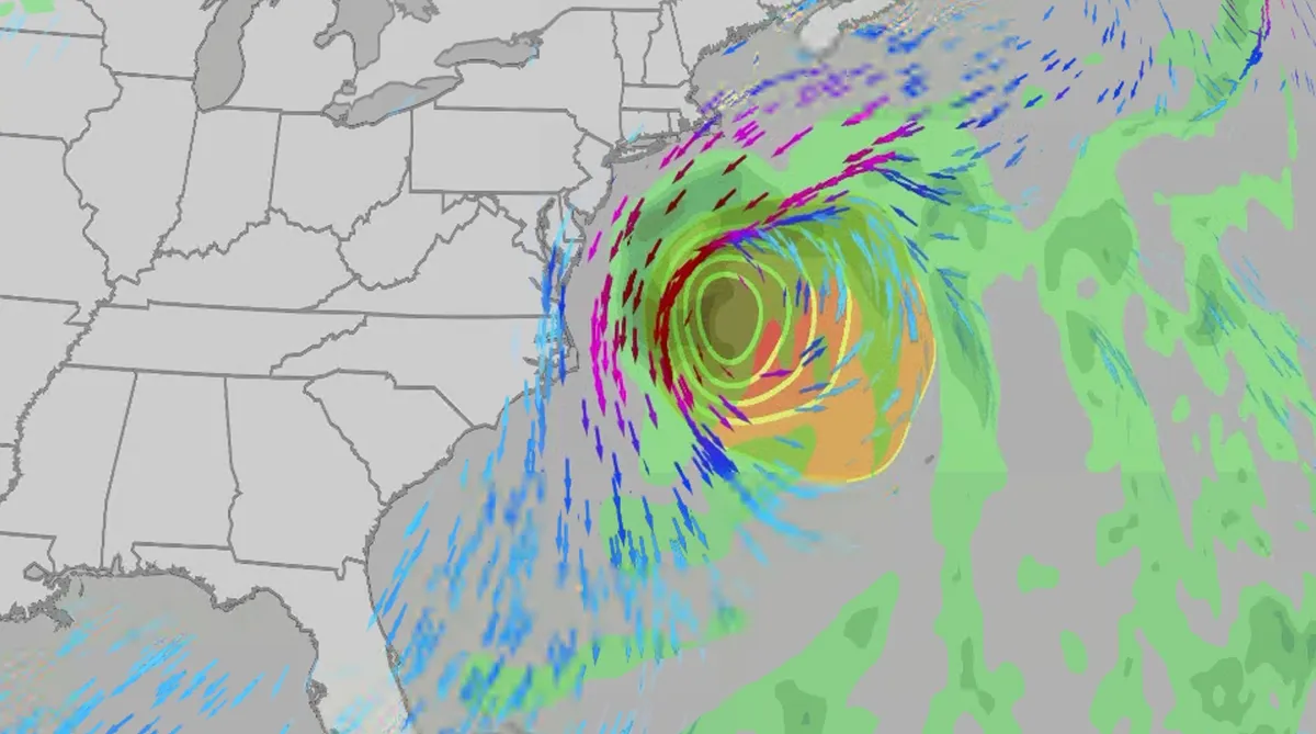
Nor' easter to bring coastal flooding, winds to East Coast
An October nor'easter is developing in the Atlantic, where it will bring high surf, rip currents, coastal flooding, winds and rain to parts of the East Coast for several days this week. The National Hurricane Center has it highlighted as an area to watch this week for potential subtropical development. However, regardless of development, this system will bring dangerous conditions to the East Coast this week. Fortunately, this system doesn't look to be as strong as the one in September. But the bad news? It could linger for much of the week, so impacts could have a longer duration than you would think. There are currently coastal flood alerts across parts of coastal North Carolina and Virginia, where anywhere from 1 to 4 feet of inundation is possible. Key takeawaysWe do not expect this storm to be as strong as the late September nor'easter. The area most likely impacted the longest appears to be from the Delmarva Peninsula to eastern North Carolina, with more models pointing to primarily eastern North Carolina.

Coastal homes burn as hot winds fuel California wildfires
Thousands evacuate Southern California as wind-fueled fires burn homesFire crews in Southern California gained ground Saturday on a wind-driven blaze that charred hills and damaged or destroyed at least six large coastal homes, allowing evacuation orders to be lifted and thousands of people to return home. The fast-moving Norte Fire sparked the previous day in San Clemente amid hot, strong Santa Ana winds that drove it into San Juan Capistrano, prompting the evacuation of about 16,000 residents. Firefighters work to douse a house fire during the Norte Fire on Friday, Oct. 16, 2026, in San Juan Capistrano, Calif.(AP Photo/Jae C. Hong)Hundreds of firefighters deployed to combat the blaze in the hills of Orange County. At one home engulfed in smoke and fire, photos showed them using hoses to try to douse the flames. Most of the evacuations were lifted Saturday evening, except for one street in San Clemente. The Norte Fire was one of several in the region hit by the Santa Anas, which blow from the interior and toward the coast.

Meet the marine technician documenting Antarctica's beauty while protecting its future
Marine technician crosses world's roughest sea to document AntarcticaFor Andrew Naslund, Antarctica is his “favorite place in the world.”He’s a marine technician for Scripps Institution of Oceanography. And while not a professional photographer, he’s capturing Antarctica’s beauty along his research journey. Andrew Naslund, Scripps Institution of Oceanography marine technician.(Andrew Naslund)The researchNaslund spends months aboard a research vessel, the R/V Roger Revelle (AGOR 24), which he describes as “basically a floating laboratory.”“The purpose of this ship is to provide a platform for scientists to reach some of the most remote reaches of our oceans,” Naslund said. A big part of his role is assisting the scientists to safely deploy and recover their instrumentation over the side of the ship. He also keeps track of incoming data, ensuring the scientists are getting the information that they came out there to get. “[We’re] a mobile weather station. So anywhere that we travel in the world, we’re collecting meteorological weather data,” he says.
0 comments
No comments yet. Be the first to share your thoughts!